
Tonto Plateau looking north, east of Tonto/Boucher Junction
Jen and I knew that we wanted to spend her (two week!) Spring Break outside, neither of us had ever been to the Grand Canyon, and it was on her list of things to do in 2009, so our choice was easy. In our usual hyperbolic fashion we took to calling the trip GC09, GCSB2k9, or other semi-random permutations of the characters G,C,S,B,2, and 9.We are a little long on enthusiasm sometimes.
Planning wasn’t bad. I simply fired up my search engine of choice, et voila! I found this gentleman’s very helpful website (http://www.bobspixels.com/kaibab.org/bc/hikelist.htm), containing a list of trip itineraries and mileages, along with suggested number of days to complete. Funny enough, opening it again just now, I see this prominent statement quite high on the page:
“Please use caution when planning your backcountry trip, check the trail descriptions and make sure you understand what you are getting yourself into.”
No thanks! I’ll just find something that fits our desired trip length and go blindly from there. Ok? Ok. Great. Thanks again.
We settled on a 4 day itinerary, tracing roughly a loop.
Day One:
Hermit’s Rest Trailhead
Dripping Springs Trail
Boucher Trail
Boucher Creek Campsite
Day Two:
Day trip to the Colorado river
Boucher Creek Campsite
Day Three:
Tonto Trail (east)
Boucher Rapids Campsite
Day Four:
Hermit Trail
Dripping Springs Trail
Hermit’s Rest Trailhead
—
Of course I immediately excluded all trips including the so-called “corridor trails” – the superhighways of the canyon – trails wide enough to walk three abreast, full of mule dung, and offering semi-luxurious accommodation (if not large campgrounds with running water) at regular intervals. We are not the bourgeois of the outdoors! We do not need your trail improvements and access to “emergency services”! Ha! The very idea of these well-trod paths seemed at once pathetic and worthy of contempt. We would instead find some random little piece of the canyon to call our own – something sure to offer a unique Grand Canyon experience, inaccessible simply by choice to those unwilling to buy a map and strike out on their own. We, you see, are explorers.
Oh, how wrong I was.
So having chosen our adventure, I dutifully sent off for permits and generally let other things in life take over, knowing that we had two months or so until the trip was upon us. Then it came: a fat envelope from the National Parks Service! We got our itinerary approved with no modifications! Success! I then dug a little deeper into the package to find that they had helpfully included brief one-page descriptions for each trail that we’d be using. Great! I love narrative. But what’s this? In the Boucher trail description the NPS opined thusly: The Boucher challenges even experienced Canyon hikers. The trail consists of tough, tedious traverses linked together by knee-destroying descents, with a section of exposed hand and toe climbing thrown in for good measure.
(me with a look of sliiiight consternation on my face).
The leaflet ended with this: IMPORTANT NOTES: The Boucher trail is arguably the most difficult and demanding of the south side trails. The overall condition of the trail, especially in the Supai and Redwall formations, presents an obvious hazard. The trail through the Supai is hard to follow when covered with fresh snow. Map reading skills are essential. The Boucher is best left to highly experienced Canyon hikers.
(me feeling a bit… what’s the word? irresponsible?, rash? over-ambitious and under-informed?)
So…. Jen and I are not precisely experienced Canyon hikers. This is our first time, as you recall. And well, Jen has this thing with heights…. Yeah… she does not “do heights”, so ummm…. TO THE INTERNET!
A blatantly tardy web search revealed trip reports where people spoke of the Boucher as a “moderately hazardous route involving a brief section of exposed scrambling”. Others, though, showing perhaps less restraint in their choice of words called it “a potentially deadly undertaking”. Well, this, as you can imagine, had me a bit worried.
Shall we try to amend the permit (he asks his ever-patient partner)? No, says she, let’s stick with the plan. I mean, they let people take this trail. How bad can it be?
With that, the weeks rolled by. Food and other sundry items were purchased at the local REI (why no dividend on food purchases?!?), reservations for fido made at the GC Kennel (no dogs allowed below the rim), and soon enough the car is packed and we are on the road, taking I-40 across the Mojave desert towards Flagstaff, killing innumerable butterflies on the way. Our hearts are light! The audiobooks are playing, the gas stations all offer a selection of cold drinks to rival that of any minor African despot’s palace, and we are on VACATION.
Our first “real” stop was Flagstaff. Neither of us had been before and we both came away really liking the town – a good progressive vibe and REALLY good Thai food will get you a long way with us, though. We planned to crash on Forest Service land north of town and south of the park, and I had secured directions to a cool-looking little spot in the shadow of Arizona’s highest point, Humphrey’s Peak, beforehand. When we got there, though (in pitch darkness), a gate blocked our way. Oh well, said I, let’s just throw a tent up here a little ways off the road. It’s all Forest Service land, so camping is permitted except where otherwise explicitly indicated. Good plan! Except for when Jenna came across what by all accounts looked like a gravesite while we looked for the best place to put up a tent. Come on, people. I don’t need this. She’s a girl. Shes allowed to be creeped out by this stuff. Me? I just have to PRETEND that I’m fine with sleeping near a gravesite in the middle of nowhere.
Well, we weren’t blair witched during the night, so the next (cold!) morning we took a beautiful walk through the forest towards Hart’s Meadow. Streams were partially frozen, the dog was running and jumping, and we were en route to adventure. After our walk, we entered the park, which looked to us a lot like a big forest. The Grand Canyon National Park isn’t the Tetons or RMNP, or any number of other parks where you can see the “why” from a great distance. Instead, GCNP is a whole lot of “oh, that’s nice” until you are literally yards away from the rim, at which point you kind of get quieter and realize that there was a reason you came after all, and oh by the way, this is pretty spectacular. So we killed the day geting a rat-sack (so rodents don’t eat all your food from your backpack), dropping the dog off, and sorting gear in our campsite in hurricane-force winds.
One cafeteria-style meal and a night of sleep interrupted by the campers next to us showing up loudly, vomiting, and then proceeding to boot and rally, the beginning of the adventure was upon us. Oh, and 4 inches of new snow was upon us as well. Seeing snow in the high desert is always really cool.

Srrrsly!
We passed the gate on the way out to Hermit’s Rest (they give you the code in your permit), and after each of us made all of our final preparations, we were on the trail at about 9am, now only patches of snow remaining but the air temperature hovering in the high 40’s. The Dripping Springs trail lets you know where you’re going in a hurry: down. The trail is like a yellow-brick road in to the canyon, replete with hand-fitted paving stones quarried locally. The trail was constructed by and for the Hermit trail’s namesake: Henry Boucher.

Boucher Stairs
Boucher was actually not a hermit at all, but that’s gonna be the rap you get if you’re a dude who builds a house damn near the bottom of an isolated corner of the Grand Canyon. The trail switchbacks down and down and down to a large sandy tarn after about 30 minutes, marking the trail junction for the Dripping Springs and Hermit Trails.

Hermit/Dripping Springs Sign
Here we stayed on Dripping Springs, but would return to this same junction via the Hermit Trail on the return. Dripping Springs gains a bit of elevation here, then begins a sometimes spectacular traverse of a very remote-feeling piece of the canyon. One never gets expansive views, but there is a lot of vertical relief to be seen. After another hour or so on the DST, there is a subtle junction with an inconspicuous sign for the Boucher Trail.

Boucher/Dripping Springs Sign
The Boucher Trail, at this point is an indistinct footpath through a drainage, providing the first taste of what an unmaintained (no trail crew in 40+ years) trail in the Grand Canyon looks like. The BT immediately cuts up and across a fairly narrow plateau, offering a completely different flora than we’d seen so far. Microclimates in the desert aren’t so pronounced as in coastal climates, but to see the subtle variations in life based on sun/shade and aspect was very cool.
The plateau continues narrowing until completely interrupted by a rockslide of car-sized boulders. The path across is trivial (for me, Ryan) but requires a bit of routefinding and easy downclimbing. We ended up stopping here to eat lunch.

First View
The mild dread of when we’d encounter the principal difficulties and exposure had not yet consumed us completely, but did accompany us through every blind turn. Jenna has a serious aversion to heights, and the trip descriptions we’d read on the internet were a recurring theme of conversation. The topo wasn’t precise about when exactly we would hit what others had decided was so deadly, since they provided elevation on an absolute basis, while trail descriptions (and experienced canyon hikers) calibrate height in the canyon according to which rock strata one is in.
")
Red flower (I am ignorant)

Lizard (again, ignorant)
Having passed the easy scrambling, both of us wanted to believe that the worst was passed. The spring in our step was dampened pretty quickly when we met another party coming up trail (the only other group we would see, in fact, on the Boucher Trail), who asked unnecessarily salacious questions like “have you guys done this trail before”, and upon hearing that we had not, informed us that “it’s like, so dangerous back there. if you slipped you might die”.
I went in to damage control mode. I pointed out that we’d read different opinions on the seriousness, that people tend to play up the excitement of something that they’ve recently done and are proud of, and finally, the fact that they did not look like wizened veterans of the canyons. These were no desert rats, attuned to the fickle balance of life and nature’s whim in a place where humans are at a natural disadvantage. Nay, these were the folk of GAP sweatshirts and non-load bearing carabiners holding myriad camp accoutrement to an already bloated external frame pack. In short, we were hearing from the farm team of canyon walkers. We, Jen and I, we were a cut above.

The descent, in retrospect
It was with some amount of dread, though, that we made progress across the next hour or so of non-descript traversing, always scouting the route ahead for where the inevitable but unenviable break came in the Supai. Finally, it was upon us – a loose gully dropping down at more than a 45 degree angle. Well, Jen soon blacked out, an emotional mixture of fear on one hand and blind trust in my ability to guide her through the ordeal on the other. From my perspective, this was a trivial 3rd class downclimb through short sandstone towers and semi-consolidated scree. From Jenna’s perspective, we were making out with Death after the lights were flippped for last call in a bar you’d never been to before but with great drink specials, all of our friends having left an hour ago. In other words, a really bad idea gone too far to abort. Suffice to say that there were alternate bouts of crying and pleading, punctuated by whatever response I thought would work best in the moment, and yes, I ran the whole range:
ANGRY: Get a hold of yourself! You need to be sharp right now! There is no place for emotion. Cry later, focus now!
EMPATHETIC: I totally get that this is scary. Just go slow and you’ll be fine.
GUIDING: Your right foot goes here. Turn around. Do this part facing the rock. This block is loose.
BARGAINING: If you do this we’ll never have to do it again. It’s over after this, babe.
CONFIDENCE BUILDING: That’s it! Great work! See, you’re doing it! Just one more step! Great! Now again, here. Goooood.
And in the end, the attitude that works most often in life was the right one here as well: calm and assertive. Jen was still freaking out, but trusting that I didn’t take her here so she could die, and we were making progress – never really stalled out long enough for her to completely melt down.
In all, the gully probably loses 300 feet of elevation, after which it dumps you pretty unceremoniously in to a broader drainage. This is the routefinding crux of the entire route, and we while we didn’t blow it, we definitely wasted some time. It’d be impossible to describe how to do it right (or even how to do it wrong), but the path here varies between pure cross country travel and very faint use trail. This is the only place where one could get cliffed out by following the wrong path, and though consequences are low if one does choose incorrectly, I think most people are mentally ill-equipped for any disappointment at this point in the day.
Having picked our way through this last tricky section, I, silently, was worrying about the amount of daylight remaining. Jen was totally baked, moving along but fully exhausted by the mental toll of the descent. Now, at least, only Travertine Canyon lie between us and our objective.
In some act of cosmic recompense, the next logical place to stop after the descent is on a pleateaued penninsula just before White’s Butte. This is a dry campsite but must be one of the most spectacular that we’d seen. Huge boulders dotted the landscape and expansive views to the east had us thinking, in our totally mentally friend state, about posting up for the night. The distance to our intended campsite convinced us to press on.
Unfortunately, we were doing our map-reading with a Trails Illustrated 100 foot contour map. While the Travertine Canyon descent looked, well, manageable, a USGS quad would have told the real story – endless swithbacks down nearly 2000 feet still stood between us and the end of our day. But hell, who am I kidding? The contours were there on my map, all 20 of them. I just didn’t want to cop to reality.
The relief of knowing that we’d passed the technical crux soon gave way to the quad-destroying reality of a 2000′ foot descent (in about a horizontal mile) to END your day. We were cooked. Talk of dinner did nothing to brighten things. Footing seemed precarious, even when it wasn’t, simply by virtue of carrying full packs on tired legs. Talk of headlamps may have happened. Honey was eaten. And finally, after a somewhat demoralizing trail junction with the Tonto (Jen was not happy to be passing in descent what we’d only have to climb to return to in order to continue the loop), we made it to a beautiful little patch of tent sites along a stream. Or rather, a creek. Boucher creek, to be precise.
We woke up the next day incredibly thankful that we’d planned a full day at Boucher Creek. Jenna, the first day, had kept saying that she felt like we weren’t TRULY in the canyon yet. Our day trip to the Colorado River proved that we were indeed IN the canyon, and could not get any more IN THE CANYON, as the freaking river was the BOTTOM OF THE CANYON by default. Overall a cool experience more for the opportunity to see the geological force that created the entire thing rather than a destination unto itself.
The rest of the day was spent scrabbling (our big weight luxury item for the trip was travel scrabble, a very thoughtful Christmas gift from John), reading, and hanging out in the little pools of Boucher Creek. There was one other group in the area the first evening but we had this incredible and remote place all to ourselves the second night.
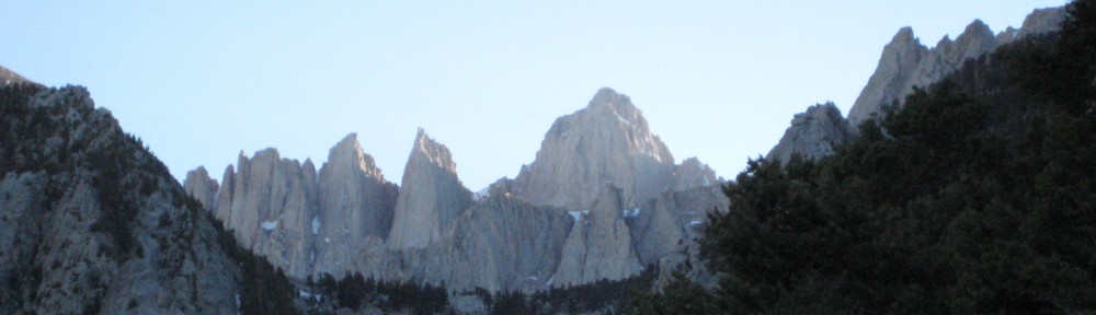
Day three dawned and found us shouldering our pack for the easiest of our hiking days: a traverse across the Tonto plateau. I had gone up on a restless-legs reconnaissance mission the day before around sunset to find one of the most magical and peaceful places I’ve ever found on the earth. Even better, it was damn near flat up there! The panoramic at the top of the post is from the Tonto Plateau.

Jen cruising the Tonto


In the end, the magic of the place was far more inspiring than the topography. Our legs were fresh and we were able to chug along at a great clip while enjoying incredible open vistas and a great selection of wildflowers. There is one sketchy section for those that don’t like heights; a weird little jog around a decomposing pinnacle/slope, but otherwise this is an area and a trail where you can make major mileage in fantastic surroundings.
We pulled in to our final campsite, Hermit Creek, fairly early in the day, jarred by the first signs of civilization. Multiple tents? Graded sites? Composting toilet (that was only kind of working…)? It felt like an RV park compared to our isolated and totally primitive experience of the previous few nights. Hermit Creek Campsite did come with the dual benefit of being situated in an incredible, improbably lush, canyon, and sitting right at the junction of the trail that would take us out the next day.

Beautiful Hermit Creek Campsite Tree
The afternoon was spent swimming in the even larger pools of Hermit Creek (where the fingerling fish nibble at you!) and, predictably, reading and playing scrabble. For the first time below the rim, wind was again a factor, brink enough that it forced us to cook inside the tent.
We had decided to go with an alpine start to beat the heat on the long climb out. Funny how a 430 wake up call is much easier in the desert than the mountains (in the mountains I’m usually cold and full of excuses at 430). Up and making our final pack preparations at by headlamp and under a bright moon, we hit the trail at first light around 530 am.
At least you know what you’re in for on a walk out of the Grand Canyon – you’re going up. The Hermit Trail “was built to serve a luxury campsite near Hermit Creek. Hermit Camp predated Phantom Ranch by 10 years, and in its heyday was complete with a tramway from the rim, a functional automobile for transportation within the facility, and a Fred Harvey chef. Operations ceased in 1930, but for two decades Hermit Camp was the last word in gracious tourism below the rim.”
The HT headed out is defined for most hikers by a feature known as the Cathedral Staircase. Unfortunately for Jenna, it was also marked by another feature: the angle of repose slope. This formerly high-tech, semi-paved, trail, without maintenance, has degraded so completely in parts that it is nothing more than singletrack beat in to a decomposing scree field. I think that without the first day’s experience, the Hermit wouldn’t have caused a second thought, but after our trip in on the Boucher, nerves were raw and some of these areas seemed daunting.
Jen and I strategized before we started the hike: we would take the flats as fast as possible but manage to breathing and heart rate on the major inclines. Soon enough we hit the Cathedral Staircase and were pushing but not redlining. Both of us had our own best reason to get out; I wanted a beer and Jenna wanted to be anywhere NOT associated with the words steep, exposed, or treacherous. The subsequent flats and steady climbs were fairly a blur. When we met a group of three ladies hiking down and asked them how long they’d been walking since the rim we were incredulous when they responded with a figure of 1.5 hours. Our exact goal or expectation for outbound hiking time has been forgotten, but we knew then that we were motoring. The dogs had been loosed. Instead of dreaming about dinner, we were dreaming about lunch, and instead of sleeping another night in the main campground on the rim, we started to talk about how far west we could drive.
Soon enough we came across Santa Maria spring (which would be a way cool dayhike, complete with rest area and ROCKING CHAIR!), ate some more honey, and began the final push. We breezed through the Dripping Springs / Hermit junction we’d passed through on the way in without so much as a pause to reflect and were back on the Yellow Brick road that had carried us in.
The climb was a slog, yes, but motivation was high. Occasional dayhikers wanted to stop and talk about where we’d been and how long we’d been in the backcountry, but Ma and Pa Kettle couldn’t compete with the allure of another bland cafeteria lunch and beers while wearing anything but trail runners.
In the end it wasn’t a cafeteria meal but a trip to the Deli that made it all worthwhile (we ate most of the food between them handing it to us and getting to the register). We were satisfied – me that I’d finally “done” the Grand Canyon (and via a respectable route, at that) and Jen simply to have survived it.
We went to the kennel, picked up a dog that had apparently been unwilling to poop for 4 full days of our absence, and spun tires back towards Flagstaff and our next destination: the East Side of the Sierra Nevada.
All those stories and more in the next posts…
